
~Milt McAuley
Distance:
7.5 mile loop trail.
Location:
Pt. Mugu State Park, in north-western Los Angeles County.
Hazards:
Poison oak, ticks, rattle snakes in summer and fall. Good year-around, but perhaps best in April-June when the waterfall runs strong and flowers abound. Avoid on the hottest days of summer.
How to get there:
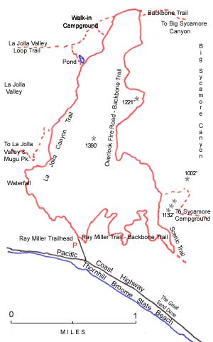
To get to Ray Miller Trailhead drive west on the Pacific Coast Highway, 22 miles from Malibu Road to La Jolla Canyon. Those coming from the Ventura area, will find it 4 miles beyond Las Posas Road. It is located across the highway from the western end of Thornhill BroomStateBeach. A fee is charged for parking, so stop at the sign. Drive about 400 yards up the canyon and park in a paved lot on the left. Water is available in the picnic/parking area; restrooms are just a few yards up the trail.
Hike description:
Like all loop trails, one may hike clockwise or counterclock-wise. Usually it’s a toss up, but here I vote for clockwise because toward the hike’s end, we come south looking at the ocean. Our view develops slowly but majestically. From 1,100-feet high on a ridge, we start down toward the floor of the canyon — just a great ending for anyone walking or riding this trail, a section of the Santa Monica Mountains Backbone Trail.
During the planning and building of the Backbone Trail, we used existing trails and fire roads wherever possible.This practice had a positive effect. We had a ready made route for a good part of the trail, particularly on State Park land and much of the National Park land.Environmentally we gained by less disturbance of pristine areas.
However, early on, we could see a problem developing at the western end of the trail. La Jolla Valley came into the Park system with a trail system in place and having an outlet through La Jolla Canyon. La Jolla Canyon is a “V”-shaped gorge having steep, rock sides. The existing trail is narrow and exciting, hanging on to the canyon wall.
Because of the terrain, hikers only are allowed on this trail. Equestrians were concerned that for them a suitable western trailhead would be far in the future. One possibility considered was to build a trail for them on the slope of the Chumash Trail further west. Many of us envision the 7,000-year-old Chumash as a national treasure. That it should be destroyed is unthinkable.
Construction of an equestrian staging area near the Ray Miller Trailhead has solved the problem. Named for the Park-Service host who for many years looked after the trailhead, the Ray Miller Trail is indeed a fitting beginning or ending of a trip on the Backbone Trail, and it comes into La Jolla Canyon.
Walk north from the trailhead on the La Jolla Canyon Trail. We will notice a trail on our right. This will be our exit from the hike. We cross La Jolla Creek, where sometimes in late winter, the water runs high. We will have had an indication of how much water is running when we drove in. About 3/4 mile from the parking lot and another crossing of the stream, brings us to the waterfalls. Until the floods of early 1998, we didn’t notice the lower waterfall because willow trees hid it from view. The trees took a beating but are slowly recovering.
We continue up the trail gaining another 250 feet on a steep narrow path. Please use care; people have actually fallen off the edge and rolled into the poison oak.
A near level trail continues upstream. From this point on until we get back to the parking lot, we wont make any left turns. In other words, turn right at every fork in the trail. We pass a fork in the trail that if taken would put us on the frying pan loop. Our next chance to go wrong is when we come near the pond. We’ll keep going until reaching the crest of a ridge overlooking Sycamore Canyon, then turn right onto Overlook Trail. True to its name, we look left into Sycamore Canyon and right into la Jolla Valley.
The trail on our left is a section of the Backbone Trail. It drops down to the Big Sycamore Canyon Trail. Up ahead we will see two water tanks, later pass by Peak 1221′, then Peak 1390′, both on our right. About 15 minutes later, as we make a sweeping turn left, we will notice the Scenic Trail to the right. After a half mile on the Scenic Trail and great views of the ocean open up, we come to the Ray Miller Trail on our right. Two miles later and 1,100 feet lower, we rejoin the La Jolla Canyon Trail at the trailhead .
This hike and 87 others (not to count the “Lower Tomol Trail”) can be found in “Hiking Trails of the Santa Monica Mountains” (6th ed., 1998) by Milt McAuley. Illustration by Janet Wilson Solum. All rights reserved.
McAuley has been leading hikes, building and maintaining trails, teaching mountaining classes, and writing about the Santa Monica Mountains for almost 40 years. His book, “Wildflowers of the Santa Monica Mountains” (2nd ed., 1996), is the essential companion to those walking in the Santa Monicas as well as to those interested in the flowers of our coastal range.